|
The use of wind as an energy source has its roots in antiquity. At
one time, wind was the major source of power for pumping water,
grinding grain and transporting goods by sailing ships. Present day
applications of wind power include water pumping and the generation
of electricity.
In 1994, wind turbines generated approximately 4 billion kWh of
electricity worldwide -- enough power for about half a million Texas
households. While utility-scale electricity generation from wind is
in its infancy in Texas, the industry is already experiencing
vigorous activity. In 1993, the Lower Colorado River Authority
contracted to purchase competitively priced electricity from
Kenetech's 50 MW wind plant in the Delaware Mountains. Royalty
payments from this project to the General Land Office (the
leaseholder of the site) will provide a new source of funding for the
Permanent School Fund. Several of the state's large investor owned
utilities, including Texas Utilities and Central and South West
Services, have also recently committed to wind power projects.
Vast areas with high wind power potential exist in Texas. Figures
6 and 7 on the facing page show average annual wind power for the
United States and Texas. Wind power is categorized according to Wind
Power Class. Wind class 1 (light blue) denotes very light winds;
higher numbers indicate stronger winds. In the United States, wind
farms are presently built on tracts with winds of class 5 (orange)
and higher. Technology currently being developed should make class 4
(yellow) wind regimes viable. Eventually, even class 3 (green) wind
regimes are expected to be capable of supporting utility-scale
ventures.
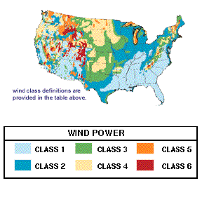
FIG. 6. U.S. Wind Power Potential.
While the strongest winds are located along ridgetops in mountainous areas, the Great Plains from Texas to North Dakota contain the preponderance of the nation's wind power potential.
| TEXAS WIND POWER POTENTIAL |
WIND POWER
CLASS |
WIND CHARACTERISTICS 50 METERS ABOVE GROUND* |
POWER
(W/m2) |
SPEED
(mph) |
COMMERCIAL
VIABILITY
|
| 1 |
 1- 1-
 1+ 1+ |
0 - 100
100 - 200 |
0 - 9.8
9.8 - 12.5 |
VERY POOR |
| 2 |
 2- 2-
 2+ 2+ |
200 - 250
250 - 300 |
12.5 - 13.5
13.5 - 14.3 |
POOR |
| 3 |
 3- 3-
 3+ 3+ |
300 - 350
350 - 400 |
14.3 - 15.0
15.0 - 15.7 |
MARGINAL |
| 4 |
 4- 4-
 4+ 4+ |
400 - 450
450 - 500 |
15.7 - 16.3
16.3 - 16.8 |
GOOD |
| 5 |
 5- 5-
 5+ 5+ |
500 - 550
550 - 600 |
16.8 - 17.4
17.4 - 17.9 |
VERY GOOD |
| 6 |
 6- 6-
 6+ 6+ |
600 - 700
700 - 800 |
17.9 - 18.8
18.8 - 19.7 |
EXCELLENT |
* Fifty meters (164 feet) is a common tower height for large wind turbines.
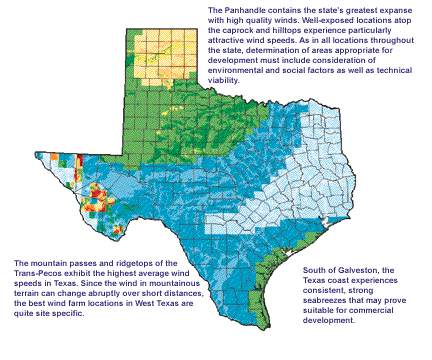
FIGURE 7. Texas Wind Power Potential.
The prevailing wind environment throughout Texas is characterized by wind power class (defined in the legend above).
The U.S. map was assembled by the Pacific Northwest Laboratory (PNL) from available measured wind data. In many areas there were no measured data. To address this shortcoming, PNL scientists partitioned the country into thousands of uniformly sized pieces and to each piece assigned a constant value for wind class. This is what gives the map its jagged, "pixelized" appearence.
The Alternative Energy Institute (AEI) at West Texas A&M University constructed the improved resolution Texas wind map as a refinement of the PNL map. It incorporates additional ground exposure information. A hilltop, for example, will experience stronger winds than the base of a valley. The AEI used elevation and prevailing wind data to compute exposure and reclassify wind power throughout the state.
While helpful, this technique is not a precise tool. Some areas on the map may, with improved data, turn out to be windier than indicated, while others may be worse. Overall, the reclassified map simply identifies promising regions in which to focus future assessment activities and development; the true potential of a specific site can only be determined from long-term, quality measurements.
The Texas map identifies three major areas with good wind power potential: the Great Plains, the Gulf Coast, and specific ridgetops and mountain passes throughout the Trans-Pecos. The electric generation potential of the windy areas of Texas is summarized in Table 3, below. These values reflect exclusions for various technical and environmental constraints. The table points out that Texas contains enough class 4 resource to produce all of the electricity currently consumed in the state. Even when utilizing only class 5 and 6 lands, wind power could generate a significant portion of the state's electricity.
TABLE 3. Potential Electricity Production on Windy Lands in Texas
| WIND POWER CLASS |
AREA (km2) |
PERCENT OF STATE LAND |
POTENTIAL CAPACITY (MW) |
POTENTIAL PRODUCTION (Billion kWh) |
% OF TEXAS ELECTRIC CONSUMPTION |
| 3 |
143,400 |
21.13% |
396,000 |
860 |
371% |
| 4 |
29,700 |
4.38% |
101,6000 |
231 |
100% |
| 5 |
5,000 |
0.74% |
21,600 |
48 |
21% |
| 6 |
300 |
0.04% |
1,600 |
4 |
2% |
| Total |
178,400 |
26.29% |
524,800 |
1,143 |
493% |
Wind is a highly variable resource, but with proper understanding it can be readily incorporated into an electric utility's generation
mix. This fact has already been recognized by Texas wind developers
and electric utilities active in the state's nascent industry. The
Panhandle, mountainous parts of West Texas, and perhaps even the
lower Gulf Coast, contain areas with winds presently suitable for
electric power generation. The number of commercially attractive
sites will only expand as development costs continue to drop and wind
turbine technology improves.
|